From Shut-Ins To Elephant Rocks
Johnson’s Shut-Ins State Park
I followed the AllTrails directions for the Shut-Ins trail, which led me to the entrance of Johnson’s Shut-Ins State Park. The main office was closed for the season, so there wasn’t anyone around to ask for help. I wasn’t entirely sure where the trail started, so I drove slowly through the park until I found a large parking area with a few cars.
As I was getting out of the van, I saw a guy walking with trekking poles and asked if he knew how to get to the Shut-Ins. He told me he had just finished a three-day hike through the mountains and said the Shut-Ins were about thirty miles away. I thanked him, realizing we weren’t talking about the same thing. I got back in the van, drove a little farther, and soon came to another lot filled with parked cars and clear signs for the Shut-Ins Trail. Finally, I was in the right place.
The trail begins near the River Store, which was also closed for the season. A quarter mile in, it splits into a loop. I took the path to the left, which leads toward the Shut-Ins.
What Are the Shut-Ins?
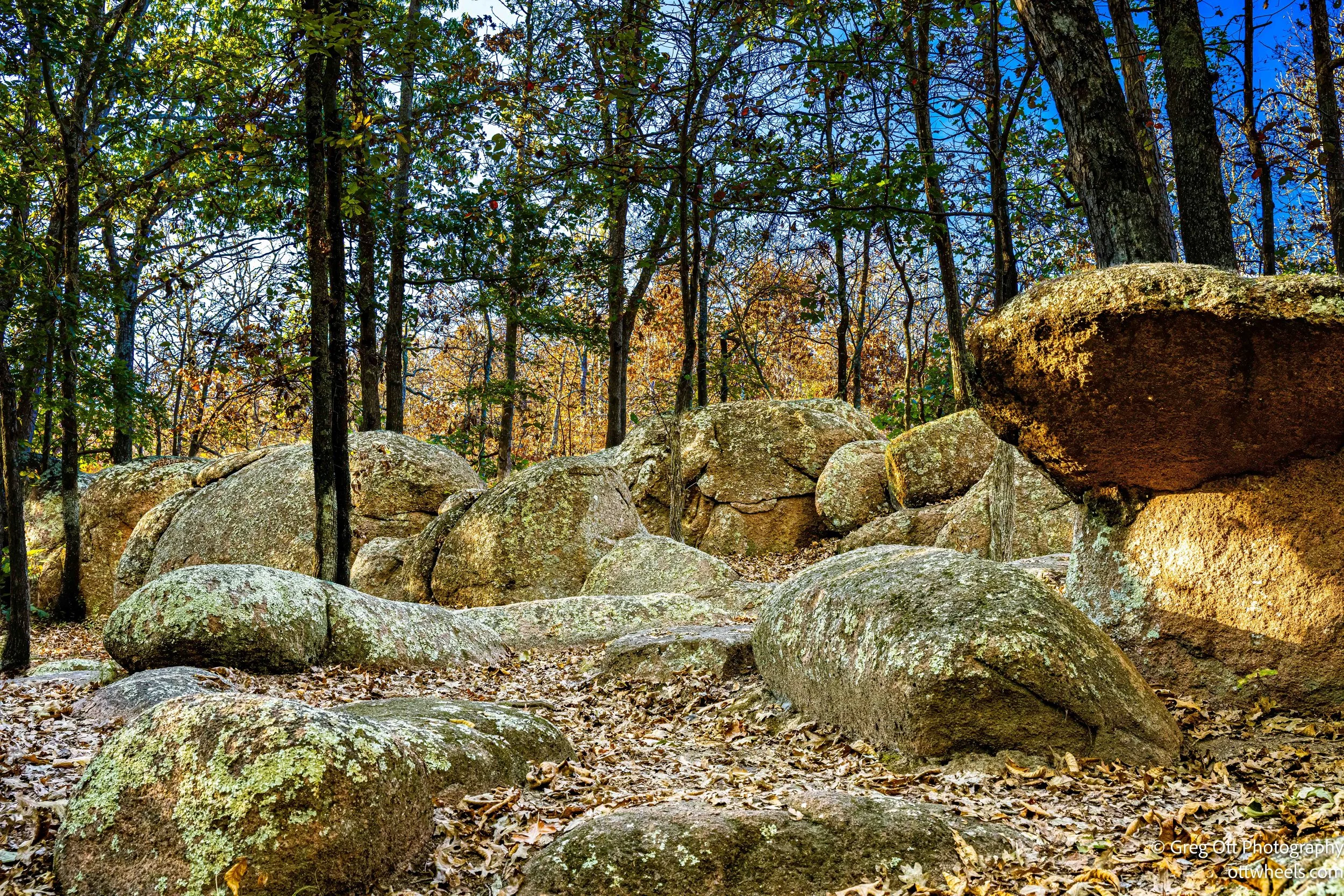
The “shut-ins” are a unique geological formation where the East Fork of the Black River squeezes through narrow channels carved into ancient volcanic rock. The name comes from the way the river is “shut in” by the hard rhyolite that surrounds it, unable to shift its course the way a river normally would. Over thousands of years, the flowing water cut deep grooves and potholes into the rock, creating a natural water park of smooth chutes, swirling pools, and cascades. It’s one of the most striking examples of Missouri’s ancient geologic history—and one of the park’s main attractions.


The Trail
The Shut-Ins Trail forms a 2.75-mile loop that winds through oak and pine forest, with sections that open to dramatic views of the river below. Some parts are narrow and hug the cliff edges, so footing matters. Other stretches cut through overgrown brush, and in early fall the vegetation can reach across the path. Long pants are a good idea—something I realized after meeting a couple coming from the opposite direction. They were both wearing shorts and showed me the scratches they’d picked up along the way.
The trail was peaceful and quiet. I stopped several times to take photos—close-ups of the flowing water over the rock channels, and wider shots of the trail weaving through the trees. Every turn offered a different angle on the Shut-Ins below. By the time I looped back to the parking lot, the sun had shifted changing the lighting on the hills around me. It was a great hike—challenging in spots, but worth every step for the views and unusual rock formations.


Taum Sauk Mountain State Park
My next stop was Taum Sauk Mountain, the highest point in Missouri. I had originally planned to hike here, but I knew I wouldn’t make it to my next destination before that park closed, so I decided to do a shorter visit instead.
Taum Sauk Mountain stands at 1,772 feet above sea level, which might not sound impressive compared to the Alleghenies or the Rockies, but it’s the highest natural point in the state. The Allegheny Mountains reach over 4,000 feet, and the Rockies climb well above 14,000 in places, so Taum Sauk is small by comparison. Still, it’s significant for this part of the Midwest, especially since much of Missouri is relatively flat or rolling.

The mountain is part of the St. Francois range, one of the oldest exposed sections of the North American continent. These ancient peaks formed more than 1.4 billion years ago from volcanic activity—long before the Rockies or the Appalachians existed. Over millions of years, erosion wore them down, leaving behind the rounded, weathered hills seen today. Taum Sauk itself is mostly made up of rhyolite, a hard, pinkish volcanic rock that resists erosion better than the softer sedimentary layers surrounding it.
Geologists estimate that Taum Sauk Mountain and the rest of the St. Francois Mountains were once as tall as the modern Rocky Mountains—possibly reaching 10,000 to 15,000 feet in elevation when they first formed over 1.4 billion years ago. Over hundreds of millions of years, wind, rain, and glacial erosion slowly wore them down. Unlike the Rockies or Appalachians, which were uplifted more recently, the St. Francois Mountains haven’t experienced significant tectonic activity since their formation. As a result, all that remains today are the heavily eroded roots of those ancient peaks—the old volcanic cores that resisted erosion longer than the surrounding rock. So when you stand on Taum Sauk’s 1,772-foot summit, you’re actually standing on what’s left of a prehistoric mountain range that was once among the highest in North America—long before the first dinosaurs or mammals ever appeared.
For Native American tribes, the area held special meaning. The Osage and earlier indigenous peoples viewed Taum Sauk and the surrounding mountains as sacred ground—high places that connected the physical world with the spiritual. The ridges were used as lookouts and gathering spots, and stories about the land’s power were passed down through generations.
Taum Sauk Mountain State Park was established in 1991 and covers about 7,500 acres. It’s managed together with Johnson’s Shut-Ins State Park, just a short drive away. The park includes the state’s highest waterfall, Mina Sauk Falls, which drops 132 feet over layers of volcanic rock. It’s also part of the Ozark Trail system, offering longer routes for backpackers and day hikers alike.
I stopped at the main overlook near the summit. The view was fine, but not as spectacular as I’d hoped. The surrounding hills are gentle and forested, so you don’t get a dramatic mountain vista—more of a calm, tree-covered horizon stretching out in every direction. Still, there’s something humbling about standing on the highest point in the state, surrounded by some of the oldest rock on the continent.
Elephant Rocks
Elephant Rocks
The Braille Trail is the main path through Elephant Rocks State Park, and it’s where I started my visit. It was created in 1967 and was one of the first state park trails in the country designed specifically for people with visual impairments. The paved path loops through the boulder field and includes interpretive signs written in both print and Braille. There are also raised maps and guide rails along certain sections so visitors can feel the terrain as they walk. It’s a simple, smart design that makes it possible for everyone to experience this incredible place.
The trail begins quietly, with scattered granite outcroppings that seem to grow right out of the ground. These rocks are part of the ancient St. Francois Mountains, formed more than 1.4 billion years ago from slowly cooling magma deep below the surface. Over time, the overlying layers eroded away, exposing the hard pink granite underneath. Water and wind worked on the cracks for millions of years, rounding the boulders into the shapes seen today.


Not far into the walk, I came across the old 1890s Engine House, a small stone building with train tracks leading straight into it. It once served as part of the Sheahan Quarry’s private railroad, which was incorporated as the Middlebrook and Graniteville Railway Company. The railway hauled massive blocks of granite down the mountain to connect with larger rail lines. Standing there, it’s easy to imagine the clang of tools, the hiss of steam, and the rumble of locomotives moving stone out of the quarry—now replaced by birds and wind through the trees.


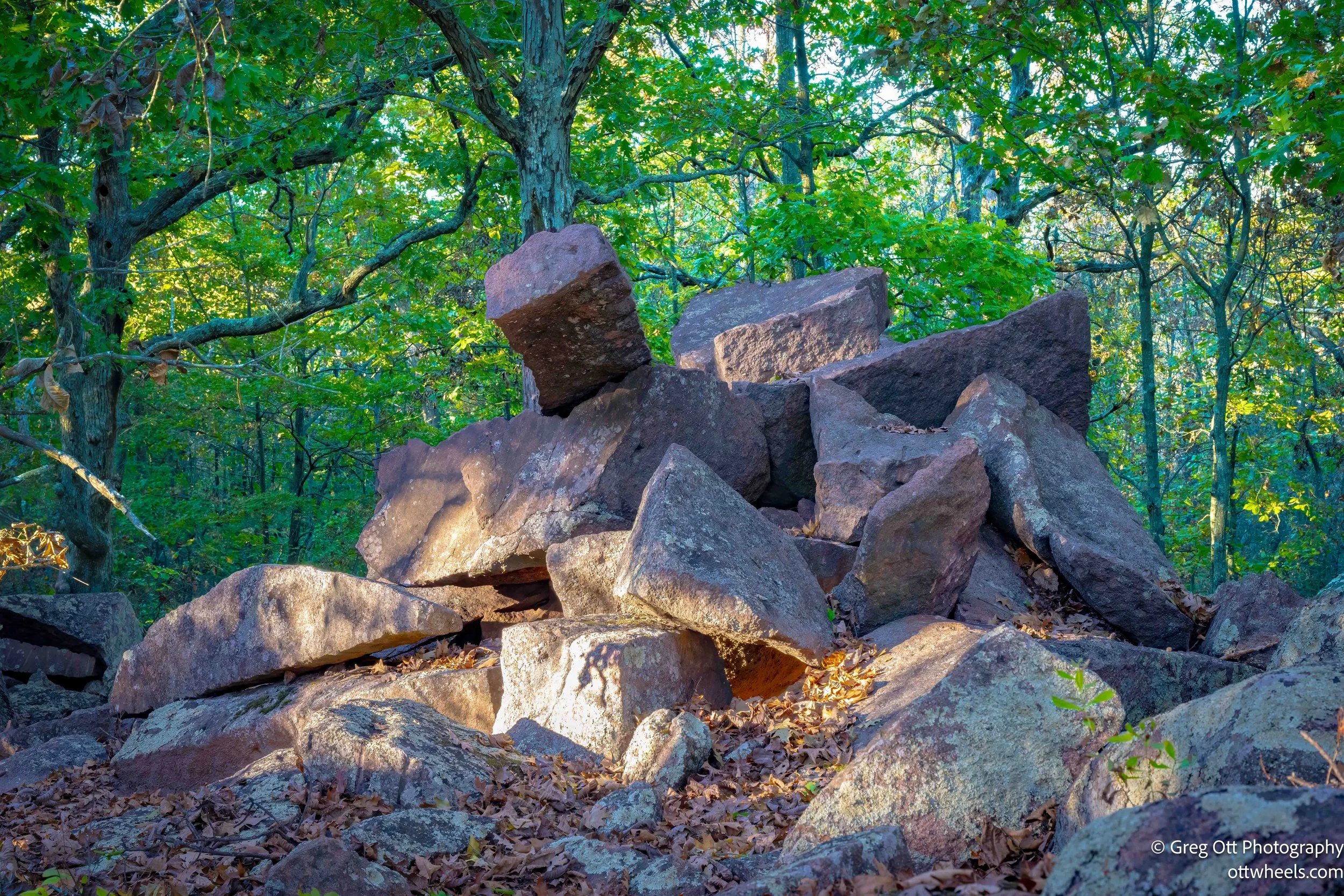
As I continued along the trail, the rocks became more scattered and round, almost playful in shape. Then, without warning, the massive boulders appeared—the Elephant Rocks themselves. They were stunning in the golden hour sun, glowing a deep reddish pink and towering over the trail like a herd frozen in place. Some of the largest are over 25 feet tall and weigh hundreds of tons. It’s easy to see how they got their name.


I followed the path through a narrow passage known as Fat Man’s Squeeze, a tight gap between two giant boulders that feels like a natural hallway. After squeezing through, the trail opened to a view of the old quarry pit on the far side of the park. The granite walls drop sharply to the floor below, and you can still see the chisel marks where workers once cut stone for building projects across the country.


From there, the loop winds gently back toward the entrance, past smaller rocks and shaded trees. By the time I finished, the sun had dropped behind the hills, leaving the granite with a softer, cooler tone. It was a quiet end to a walk through one of the most geologically fascinating—and historically layered—places in Missouri.
I found a Missouri State Conservation Area boat launch parking lot about 20 minutes away. The sun was setting as I pulled in.

Road To Conservation Area
The large parking lot was empty and I grabbed my camera. The was water was placid with a few ripples from fish going for insects on the water. The orange, blue and green tones were intense and saturated. There were no cars, only the sounds of some frogs jumping, geese flying over the water, and an owl in the distance.


