Lewis & Clark Interprative Center
I left my quiet site in Lake Sakakawea State Park and headed toward Washburn, ND. On the way, I crossed the Garrison Dam, something I hadn’t even heard of before this trip. It’s enormous—over two miles long and more than 200 feet tall—one of the largest earthen dams in the world. Built in the 1940s and 50s, it turned the Missouri River into Lake Sakakawea and still provides power, flood control, and recreation today. Driving across, I couldn’t help but feel a little awestruck—the lake spread out like an inland sea on one side while the river kept flowing south on the other. Unfortunately, there was nowhere to pull over for photos, so I just had to take it all in from behind the wheel.
I made it to the Lewis & Clark Interpretive Center before noon and spent time making lunch and then cleaning all my lenses and camera. I stepped out of the van to grab some photos of the sky to check if the cleaning worked. Shooting the blue sky at a small aperture makes any dust on the sensor show up as little black circles, and it’s an easy way to see if the sensor is truly clean.
I entered the Center which is part of the National Park Service. I was greeted by a woman that seemed to really enjoy her job at the front desk. She knew the center well and sincerely seemed to be happy that I was visiting. There were guided tours, but I decided to do my own self-guided tour, reading the plaques as I went. I paid my $10 entrance fee which also gave me access to the Fort Mandan Historic Site two miles away.
Lewis & Clark Interpretive Center
The center does a solid job of putting the expedition into context. It’s not overwhelming in size, but it’s packed with the kind of details that make the story feel real. The galleries cover the Corps of Discovery’s time here, their relationship with the Mandan and Hidatsa, and the bigger cultural shifts that followed. Standing inside, you quickly realize this wasn’t just a stopover for Lewis and Clark—it was a turning point.
One section focuses on how little the explorers understood about the land and animals they encountered. Lewis wrote about “white, red, and gray bears,” convinced he was describing different species. In reality, the “gray” was the grizzly, the “white” was often a pale or blond grizzly, and the “red” was a cinnamon-colored black bear. They weren’t new species at all—just color variations. It’s a reminder of how unfamiliar this territory was to outsiders, and how much they depended on observation to make sense of it.
The deeper story here, though, belongs to the Mandan, Hidatsa, and Arikara. The exhibits show their role as farmers and traders long before the expedition. Corn, beans, squash, and sunflower seeds thrived in the fertile bottomlands, stored in underground caches that kept food secure through the winter. These crops sustained villages for centuries and provided Lewis and Clark with food knowledge they badly needed. Nearby Fort Clark later became a hub of trade and cultural contact, but it was also a place of tragedy when the smallpox epidemic of 1837 swept through, killing most of the Mandan and devastating their neighbors.
Art plays a big role in how the center tells these stories. Karl Bodmer’s 1830s illustrations hang on the walls, showing earthlodges, clothing, and ceremonies with detail that goes far beyond words. His work gives faces and forms to the same people whose villages Lewis and Clark described. When you compare those images to the mounds and reconstructed lodges at Knife River Indian Villages, the past feels less like an abstract history lesson and more like a community you can still almost see.
Fort Mandan itself has been reconstructed nearby, giving a sense of what life was like for the Corps during the winter of 1804–1805. The stockade, blockhouses, and cramped rooms show how they survived the cold months—repairing gear, gathering information, and preparing for the next leg of their journey. It was here that Sakakawea and Charbonneau became part of the expedition, changing the course of what came after.
Before leaving, I walked through a temporary exhibit called Coal Country: The Transformation of Fly Ash. It brought the story into the modern era, using art created from coal byproducts to comment on energy, land use, and change. It was a fitting end to the visit. From the bears Lewis puzzled over to the seeds that sustained villages, from Bodmer’s images to the scars of smallpox, and even to coal ash transformed into art—the Interpretive Center pulls all of it together. The Missouri River runs past the bluff outside, just as it did then, tying centuries of stories into one place.
Fort Mandan
I left the Center and headed down the road to the reconstructed Fort Mandan. This is the location where Lewis & Clark stayed through the winter of 1804–1805. I joined a guided tour led by a Sioux Indian guide who was both articulate and deeply knowledgeable.
He had a real passion for the history of the Corps of Discovery and, interestingly, was also an enthusiastic powder gun collector. That interest came through as he described how the men lived day to day at the fort—everything from the constant maintenance of weapons to the routines of cooking, repairing clothing, and preparing for the next season’s journey.
One of the most fascinating parts of the tour was his story about the American flags carried by Lewis & Clark. Unlike the familiar stars and stripes, these “Indian Peace Flags” had a blue field with a painted eagle clutching arrows and an olive branch. The U.S. government produced and distributed them in large numbers during Jefferson’s presidency, using them as symbols of friendship and diplomacy. Lewis & Clark handed them out along with peace medals during councils with tribal leaders, including the Mandan and Hidatsa. Hearing this explained on-site brought to life how the expedition balanced survival with diplomacy—exchanging gifts, sharing meals, and building relationships that helped them endure a harsh North Dakota winter.
Our guide also showed us the kind of device Lewis & Clark used to measure distance—a surveyor’s chain. It was a simple tool made of 100 small metal links hooked together, stretching 66 feet in total. By laying it out again and again, they could calculate distances with surprising accuracy. Ten chains equaled a furlong, and eighty chains made up a mile. It’s hard to imagine dragging that thing across the prairie, but it was a key part of how they mapped the route west. He told us, that their measurement were off a total of 10 miles.
After the tour, I headed back to the Interpretive Center to complete the tour.
Bismark ND
I headed into Bismarck to pick up a bunch of Amazon packages at UPS. All five were there, everything in working order, so I loaded them into the van and drove downtown for dinner. Something was happening on the street—I thought it was live music and got a little excited to check it out. Parking was easy a few blocks away, and I grabbed my camera bag before heading back toward the noise.
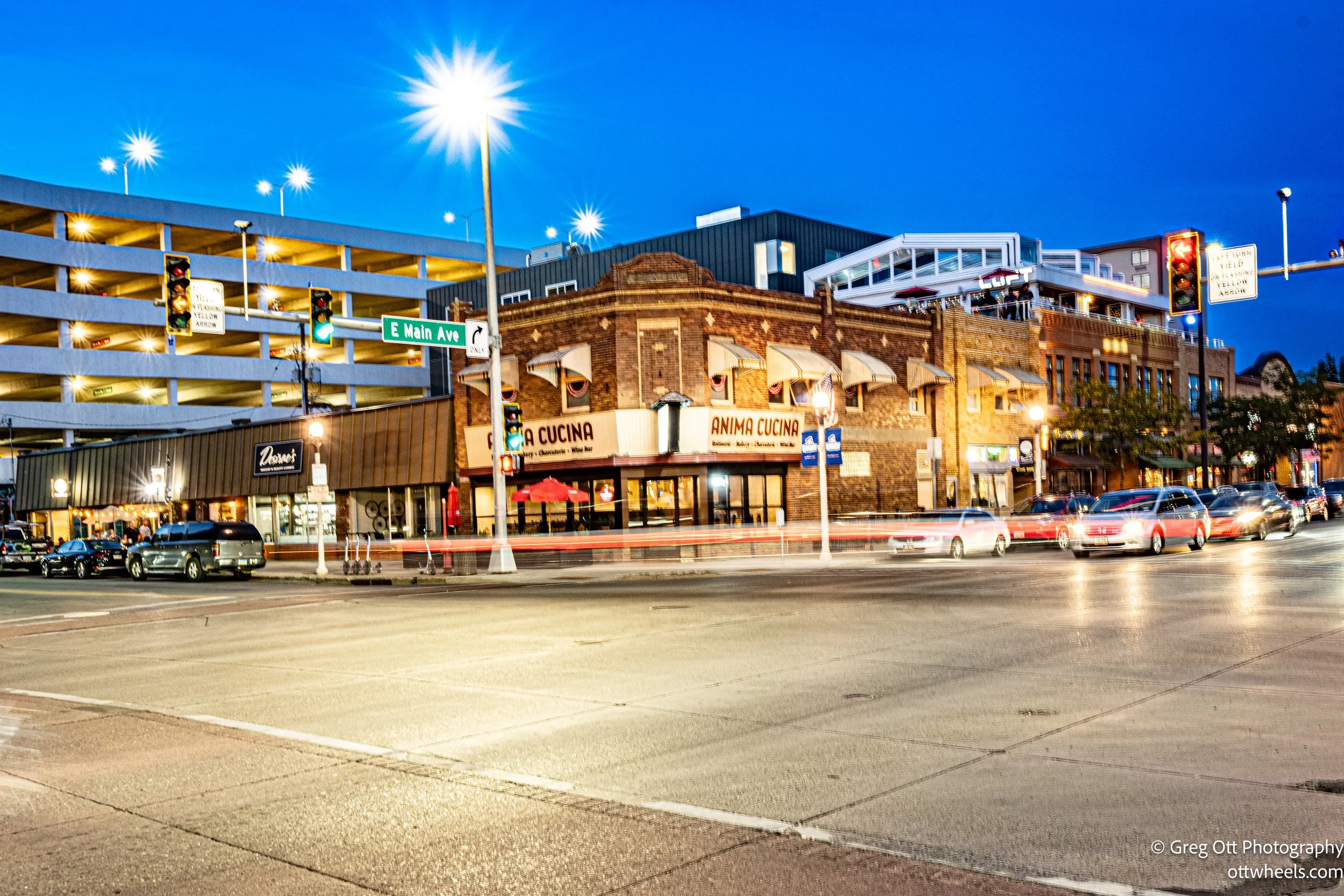
The Italian restaurant I was aiming for sat on the corner, diagonally across from the event. What I thought was music turned out to be live wrestling. I passed on that—for the moment—and stepped into the restaurant, where I found myself the only customer in the front section. It felt like a little side street place in Florence Italy. The menu was intriguing, and I went with mushroom gnocchi loaded with garlic and squid ink, plus a kale and parmesan salad. A chocolate stout rounded it out, and for dessert I ordered tiramisu with an espresso. The espresso was perfect, but it was also a mistake—I’d be up later than usual. Still, the energy outside on a warm summer night made it worth it.
Anima Cucina - Italian Restaurant
After dinner I crossed the street to take in the spectacle of “Professional Wrestling.” This wasn’t WWE-level, more of a mid-market production, but the crowd clearly knew the wrestlers. I arrived just in time for what the referee announced as the “big event.” One wrestler came out through smoke, grabbed the mic, and started heckling the crowd. Then the reigning champ strutted in with his belt. The match opened with the champ tossing his opponent out of the ring, and soon they were brawling down the street, pretending to slam each other into poles, fences, and parking meters. It was obvious they had choreographed it, but still entertaining in its own way. Photographing the action was tough, so I focused on the crowd instead—diehard fans in chairs cheering loudly, curious bystanders stopping to shake their heads, laugh, or point. Honestly, the people-watching was far more entertaining than the match itself.
I rounded out the evening with some street photography—reflections in windows, people cruising in souped-up cars and trucks, bar crowds spilling onto sidewalks, and late-night walkers. My camera battery died before long, and I hadn’t packed the backup. All that caffeine-fueled energy would have to find another outlet.
Around 10:00, I pulled into site #103 at Abraham Lincoln State Park, about 25 minutes outside Bismarck. The campground was surprisingly quiet, and my site sat right on the water with a beautiful view of the reflections shimmering on the surface. I read for a while, then tried to sleep. It took some tossing and turning, but eventually I drifted off.


