Harpers Ferry - Day 2
I woke early at the boat launch on the Potomac River miles from the Harpers Ferry. Charles Town, WV was a few miles away and I stopped at Sibling Coffee Roasters for breakfast and Coffee. The café sits on the main street going through town. There was one customer sitting at a table keeping warm. The coffee and food were good, but the owners didn’t seem to know how to interact with people. No communications, no good morning, basically no interactions with any customers. I was there for 30 minutes and it was the same with the other four cutomers. A woman tried to make conversation with the woman behind the counter.They responded by cutting the conversation short. The woman looked at me, made a funny face and shrugged her shoulders.
I headed to the Visitor Center at the National park to check if they had hiking maps for the trails above Harpers Ferry and to check if there were any issues hiking the trails. Again, the staff were extremely helpful. They recommend hikes, gave me information on trail conditions, difficulty levels, and what I would see on the trail.
Maryland Heights Loop Trail
I was feeling energetic and decided to hike the trail to the Fort at the top, and starting from downtown Harpers Ferry, the climb up to Maryland Heights feels like walking straight out of a quiet river town and into a long uphill argument with gravity. The trail starts off gentle, following the old roadbed out of town, but the warm-up is short. Soon enough, the grade kicks up, the rocks get bigger, and you start wondering how on earth Civil War soldiers dragged cannons up this thing. It is steep enough with a camera bag and good boots; imagining men in wool uniforms inching upward with artillery makes the whole mountain feel a little more impossible.


During the Civil War, Maryland Heights mattered because it looks straight down onto the confluence of the Shenandoah and Potomac. Whoever held that ridge controlled the town, the rail lines, and the river crossings. The Union built a fort on the top—more earthwork than architecture—but its placement mattered more than its appearance. Lincoln himself tried to hike up during a visit to review the troops. He made it up the lower slopes, but when he hit the section where the trail rears up sharply, he sensibly turned around. After climbing it myself, I understand exactly why. Even with clear weather and modern shoes, that stretch is no joke. The leaves had piled up over the rocks when I went, and I was slipping and sliding like I was on ball bearings. If the president of the United States in 1862 said, “Nope, that’s enough,” I’m not judging him.


Reaching the upper ridge feels like earning something. The trail stays rocky—classic Mid-Atlantic, uneven, ankle-testing terrain—but it opens just enough to offer glimpses of sky and distant ridges. The remains of the fort sit quietly among the trees, understated but significant. Nothing flashy, no reconstructed walls—just the shape of a defensive line built by exhausted men who somehow hauled guns up a mountainside most of us can barely hike unburdened.


After the summit, the trail leads down the hill to Maryland Heights and the views out over Harpers Ferry, and continuing to the overlook is the real payoff. The weather on the hike was perfect—bright sun, crisp air, and that sweet spot where you never think about adding or removing a layer. When the trail finally bends toward the cliff edge and the view opens, the whole town of Harpers Ferry drops into place below: the two rivers meeting, the rail bridge cutting across the water, the buildings tucked into that narrow point of land. It looks almost unreal from up there, like the town arranged itself just for the photograph.


To return, the trail leads back up the mountain and then decends back towards Harpers Ferry. The whole loop blends effort, history, and scenery in a way that feels honest and earned. Every step reminds you why this mountain mattered then and why it still pulls people up here now.


The Rabbit Hole
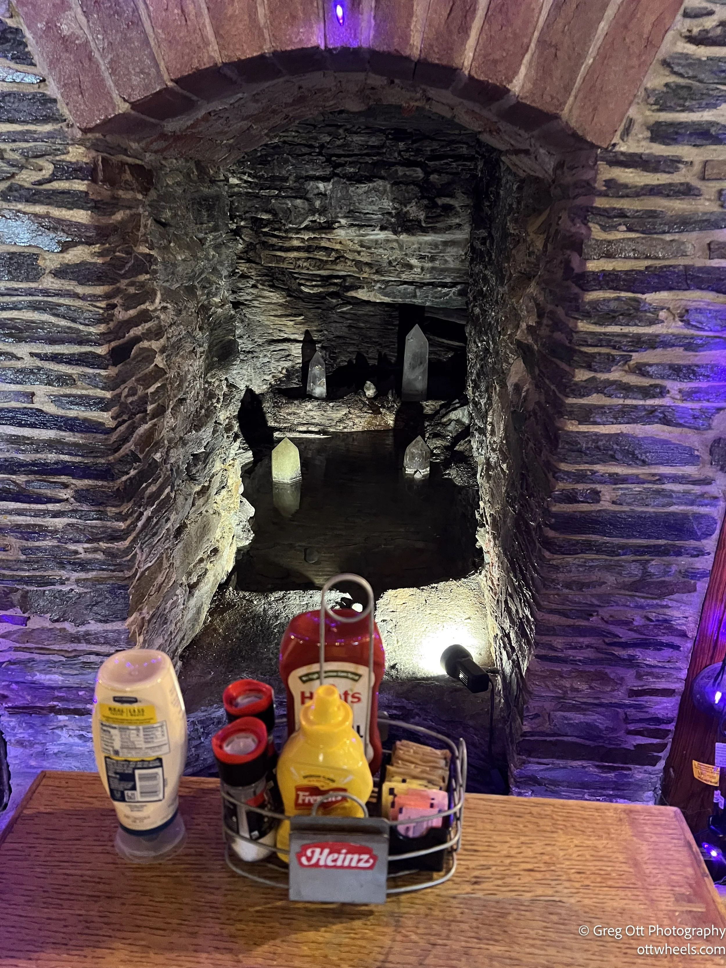
After such a long hike, I decided I’d earned a very late lunch. I wandered back into town and ended up at The Rabbit Hole, right in the center of Harpers Ferry. It’s the kind of place you walk into and immediately feel a little curiosity tug at you. The building is old—stone walls, odd corners, floors that have definitely seen a century or two—but the inside has this fun National Park theme. Every wall has signs from different parks: vintage-looking metal ones, wooden trail markers, old-style graphics you’d recognize from visitor centers. It gave the place a casual, almost ranger-station-meets-café vibe, and it fit Harpers Ferry perfectly.


I didn’t notice the spring at first. It’s tucked into a stone alcove that looks like an old fireplace. My waitress mentioned it, and when the couple sitting near it left, I went over and saw the water quietly trickling through the rock with a few large crystals set around it. Easy to miss, but once you know it’s there, the whole place feels a little different.
The menu was exactly what I needed. I ordered the red rice and bean burger with barbecue sauce, onions, and lettuce, fries with no salt, and a Big Timber Porter from Elkins. Solid meal. I started out in one of their soft leather chairs, sank straight into it, and immediately moved to a normal chair so I could actually reach the table.
My new waitress was outgoing and easy to talk to. She had two kids, was very spiritual, and said the spring gave the restaurant its good energy. We talked about yoga and traveling—both things she loves. She told me this was the off-season, that things pick up around the holidays and then shut down for a bit. She was glad West Virginia was funding the national park during the shutdown; it kept people coming through town.
With good food, national park signs on the walls, and that spring quietly running inside a historic building, it felt like the perfect way to end the day.
It was close to 3 p.m. when I headed back to the van at the train station lot. A freight train came roaring through at a speed that made the whole place feel way too close to the tracks. If anything went wrong at that pace, the station wouldn’t stand a chance. I grabbed my camera and tried for a few shots. The train was moving so fast that even the slightest shutter delay added motion, but it was long enough—and had extra engines in the middle and at the end—that I had plenty of chances. A man nearby had a Cannon camera around his neck, so I said, “Interesting photos.” He smiled and said, “That’s every day in Harpers Ferry.” I nodded and wished him a good afternoon.


Antietam National Battlefield
I headed to Antietam National Battlefield, the site of the bloodiest single day in American history. I was hoping to stop at the National Park office to get some background before walking the grounds, but it was closed—unlike Harpers Ferry, the local government here hadn’t stepped in with funding. The parking lot was mostly empty, and the wind was strong enough that it felt like the place was trying to remind me this was not a peaceful field in its past life. I walked the grounds anyway, hoping to catch a few sunset shots. The light was good, the sky was interesting, and the wind made everything feel a little more dramatic.
I didn’t have time to tour the entire park, but I stopped at several monuments, the Dunker Church, and a number of plaques marking where specific regiments fought. Antietam is one of those places where you can stand on a quiet patch of grass and know something enormous once happened right under your feet. The battle took place on September 17, 1862, when the Union Army under George McClellan finally caught up with Robert E. Lee’s forces after the Confederates pushed into Maryland. Lee was hoping for a major victory on Northern soil—something that might sway foreign powers to recognize the Confederacy or push the North toward peace negotiations.


What followed was absolute chaos. The fighting swept across cornfields, farm lanes, orchards, and fences, shifting back and forth through three major phases: the morning fight around the Cornfield and Dunker Church, brutal midday combat along the Sunken Road—later called Bloody Lane—and finally the afternoon assault at Burnside Bridge. By the end of the day, roughly twenty-three thousand soldiers were killed, wounded, or missing. The lines barely moved, but the cost was staggering.


Even without the Visitor Center open, you can feel why this battle mattered. The Union didn’t destroy Lee’s army, but they stopped his first northern invasion, and that was enough for Lincoln to claim a strategic victory. It gave him the political momentum he needed to issue the preliminary Emancipation Proclamation, turning the war officially into a fight against slavery and closing the door on potential foreign support for the South.
Walking those fields at sunset, with the wind pushing hard across the open ground, it was easy to imagine how exposed soldiers must have felt here. No movie soundtrack, no crowds, just open space and a long, heavy history waiting quietly in the landscape.
I headed to Planet Fitness for a shower and a HydroMassage. My muscles were sore and I knew that would help. By the time I came out, it was already dark, so I made dinner in the van. There were two large trucks parked nearby, and the lot was quiet. Since the gym is open twenty-four seven, I decided to just stay there for the night.
