Riverfront Trail-St. Louis
I woke up south of St. Louis at a Cracker Barrel in Herculaneum, MO. After a quick bowl of cereal, I drove north toward the city. I was a little apprehensive — I’d be driving into the heart of St. Louis, and for some reason, I couldn’t quite get a bead on where the Riverfront Trail actually began downtown. Every map I checked seemed to show only the northern end.
To make things more confusing, AllTrails and a few other apps indicated that sections of the trail were blocked, but none specified exactly where or for how long. I decided to head toward the Arch and figure things out from there. When I arrived, I was surprised at how easy parking was — plenty of open spaces just three blocks from the Arch. It was Sunday, and the meter said parking was free all day.
It took about 45 minutes to get the bike set up, check the gear, and confirm my route. I was only two blocks from the trail entrance. I started out heading south along the Mississippi River. There were a few walkers and cyclists, and the path looked freshly paved in this stretch. The Arch rose to my right, gleaming against a pale blue sky. I followed the trail south until it ended — now I knew exactly where the southern trailhead was.
At the trailhead, I stopped to photograph some graffiti with a theme. It seemed like this was legal graffiti on the concrete walls. The colors were alive—a wild, interconnected series known as the “Five Deadly Vandals.” Each piece had a style and power related to a type of reptile (snake, frog, lizzard, etc.). Their scaled bodies twisting through lightning bolts and smoke. I didn’t know what I was looking at at first—only that it was mesmerizing, this clash of art and concrete along the river’s edge. Later, I learned this section is probably part of Paint Louis, the city’s enormous outdoor graffiti event that turns the floodwall into a living, ever-changing gallery. The “Five Deadly Vandals” felt like a perfect fit for this gritty, creative space—mythical creatures born from steel, water, and imagination.


Most sources listed the full length of the Riverfront Trail as somewhere between 12 and 15 miles, so I turned around and began pedaling north to see just how far it would take me. The first few miles north of downtown pass through the shadow of the levees and the steel bones of the city. Freight trains clanked along nearby tracks, and the air carried that mix of river water, oil, and rust that seems permanent in old port cities.
The Captain Returns
Along the St. Louis riverfront, I stopped my bike to photograph and read the “Captain Returns” plaque, which marks the spot where Lewis and Clark completed their expedition after more than two years of exploration. Standing beside the Mississippi, it was easy to imagine their boats drifting back into this very stretch of river in 1806, greeted by the city that had sent them west in search of the unknown. The plaque—and the nearby statue—commemorate not just their return, but the closing of one of America’s greatest journeys.


The Gateway Arch was there as well, and I couldn’t resist grabbing a few shots. The moon hung perfectly beneath it—an incredible sight to the naked eye, though just a tiny speck in the photo (removed with Lightroom). It never ceases to amaze me how different a photograph can be from what our eyes and mind perceive. Neither truly captures reality, but each offers its own kind of perspective.

The trail followed the floodwall, where bright murals and fading graffiti competed for space. Every so often, I caught glimpses of tugboats pushing barges upriver, their engines echoing off the concrete. It wasn’t what you’d call scenic in the traditional sense, but it was raw and real — an industrial backbone that showed a side of St. Louis most visitors never see.


Farther north, the path climbed slightly to the top of the levee, giving me a broad view of the Mississippi on one side and a patchwork of factories and scrapyards on the other. Old brick warehouses stood beside modern steel mills, and beyond them rose the stacks of the old Laclede Power Plant — now an arts and events space. I stopped for a few minutes to take photos of the weathered buildings, the smokestacks reflected in the brown-green river. The sound of machinery blended with the cry of gulls overhead, and it struck me how this mix of decay and renewal is what gives St. Louis its character.


As I continued north, the city slowly gave way to open spaces — wetlands, cottonwoods, and the faint smell of mudflats after rain. Parts of the trail run right along the Chain of Rocks Canal, where the river splits around a long, narrow island. I passed quiet stretches where the only sound was the rush of water and the rhythmic hum of my tires on the pavement. Occasional interpretive signs described how the levee system and canal were engineered to keep barge traffic moving year-round. It was a reminder that the Mississippi isn’t just a river here — it’s a working highway that keeps the center of the country alive.
Chain of Rocks Bridge
At first, I wasn’t entirely sure what this odd old bridge was. From a distance, its rust-colored trusses stretched low across the Mississippi, and the sharp bend in the middle looked almost accidental—like something patched together from two separate spans. I had to look around for signs before realizing I was at the historic Chain of Rocks Bridge, once part of the original Route 66. The more I read, the more fascinated I became. It wasn’t just another river crossing—it was a living piece of American road history, preserved for cyclists and pedestrians like me to experience at a slower pace.
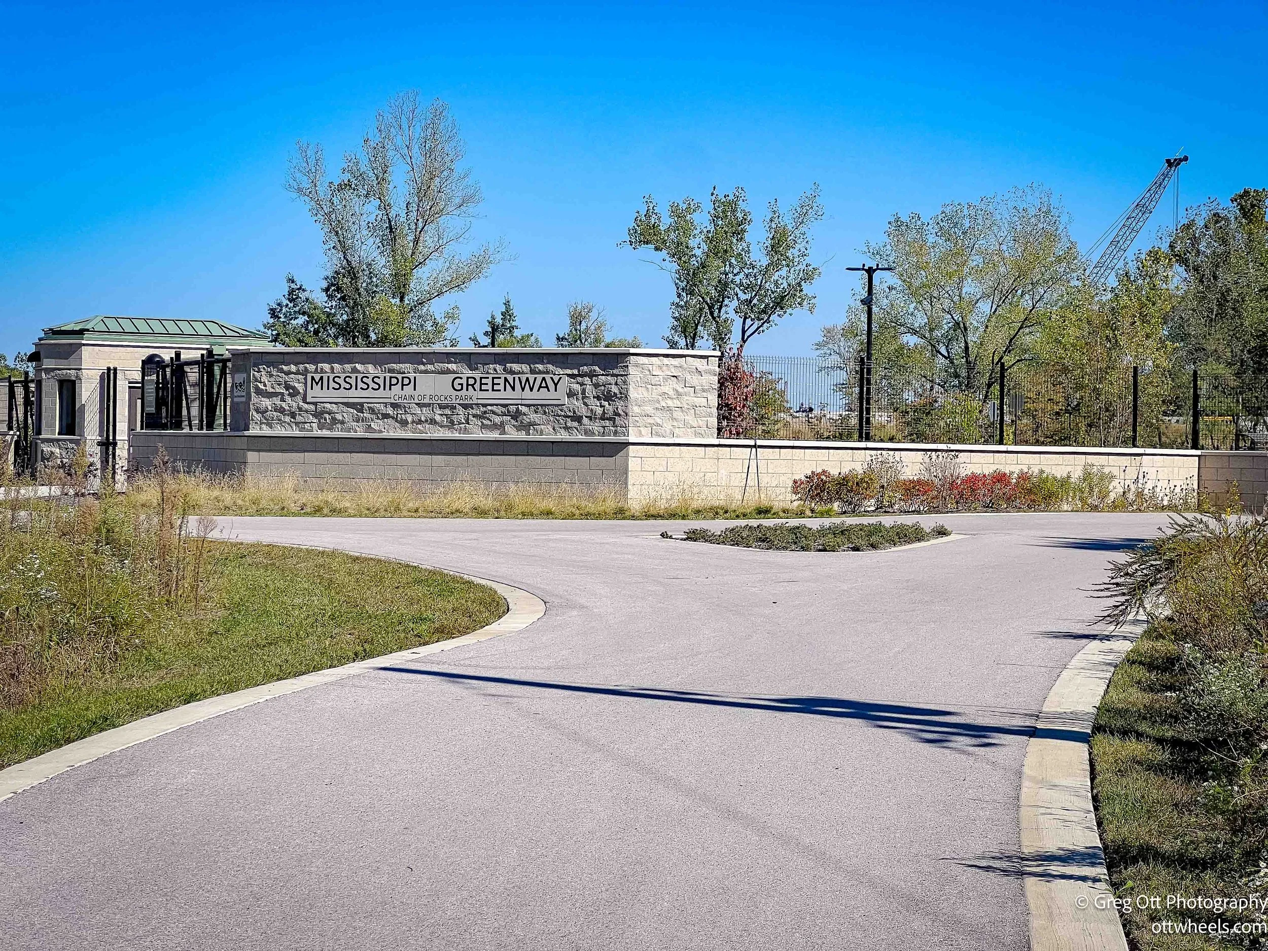
Right before the bridge on Missouri side of the Misssissippi, there’s a brand-new entrance area with a paved parking lot, restrooms, and a small gatehouse (Mississippi Greenway). The setup looked recently built, with fresh landscaping and a clean, modern design that contrasted with the aged steel of the bridge itself. The gatehouse wasn’t manned when I arrived, but it looked like something meant parking control. Standing there, it felt like this place was preparing for a new wave of visitors—perhaps as part of a larger regional bike network still taking shape. It’s the kind of infrastructure that hints at vision: connecting people, trails, and towns across the Mississippi corridor.
Once on the bridge, I pedaled slowly, stopping often to take in the view. Just to the south, two castle-like stone towers stood in the water—St. Louis’s historic water intake structures.


They looked straight out of an old fairy tale, their reflections shimmering in the current.
Then came the 22-degree bend, the part that gives this bridge its soul. I stood there for a while, picturing what it must have been like to drive across when cars rumbled over the steel deck and the river below was a lifeline of trade. That bend wasn’t a flaw—it was an elegant compromise, designed to keep river traffic safe through this rocky stretch. As I rolled off the far end and into Illinois the landscape changed quickly. The bike path ended. I was standing reading some history of the bridge and a woman asked if she could squeeze in to get a selfie. She then asked if I knew how long the bridge was. I said, “I’m guessing about a mile.” As I continued to read, a guy came up and I asked if he knew how long the bridge was. He didn’t. As I peddled onto the bridge, he yelled out, google says it’s a mile long. I gave him a thumbs up. I was on my way back to the arch about 14 miles away.


Mary Meachum Freedom Crossiing
On my ride back along the Riverfront Trail, I stopped at the Mary Meachum Freedom Crossing, a quiet but powerful historic site on the banks of the Mississippi River. In 1855, Mary Meachum—a free Black woman and community leader—helped organize an attempt to lead several enslaved people across the river into Illinois, where slavery was illegal. The group was discovered before reaching safety; some were captured, but others made it to freedom. Meachum was arrested for her role, yet she became a lasting symbol of courage and conviction. Today, the site includes interpretive panels and a small visitor center by the river, though it was closed when I passed on a Sunday. Standing there, looking across the same waters she once faced, I could feel the weight of what that crossing meant.

I had stopped to eat an energy bar and beside me was a camp. A young woman was living here. I took the photo when she went back inside.

Along the path, I kept seeing signs that read “Bollards Ahead.” I didn’t know the term, so I looked it up later—it refers to short, sturdy posts, usually made of metal, concrete, or heavy plastic, used to block or control vehicle access. I also passed several levee doors, which I assume are closed when the river floods. It’s incredible to imagine how much water fills this riverbed when the Mississippi rises to the height of the levees and dikes.


I eventually made my way back to the Gateway Arch and spent a little time riding along the tree-lined paths that wind through the park. The Arch was closed to visitors due to the government shutdown, so I simply enjoyed the quiet surroundings before realizing my van was parked at the far corner of the park and heading that way.


I left St. Louis and headed north toward Hannibal, Missouri. By evening, I found a quiet spot for the night at the Edward Anderson Conservation Area, just south of town—a peaceful stretch of woods that offered a welcome break after a long day on the road. Near the parking lot, I noticed a tent tucked into the trees that looked almost permanent, so I parked at the opposite end of the lot where the canopy opened up to the sky, perfect for using Starlink.